Thursday, December 22, 2016

Golden Gate NRA -- Alcatraz Edition

Golden Gate NRA encompasses about 20 different sites around the Golden Gate area, providing activities from military history to camping to nature viewing. During my short stay in San Francisco, I had the opportunity to visit four of those sites.  I decided to walk from San Francisco Maritime NHP downtown to Fort Point NHS, what I thought was only about a 2-mile trip.  It turned out to be a 3.5-mile trek (7 miles round trip), but if you're up to it, I highly recommend it. I walked up the steep rise to the upper green of Fort Mason, then down the stairs into the heart of the historic Army post. From there, a little farther down Marina Ave on my way to Fort Point, I traversed Crissy Field, an expansive open space for beautiful beach views or just relaxing.


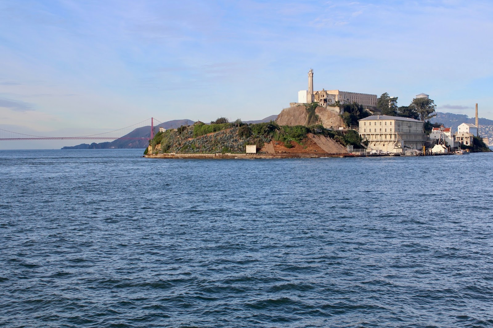
Besides taking in spectacular views of its namesake, however, the most popular attraction within Golden Gate NRA is Alcatraz.  I have always had a bit of a fascination with the place -- a prison we sent the most hardened criminals to and one that was said to be unbreakable, despite many inmates' best efforts.


The Cell House from halfway up from the dock.  The Cell House sits about 300 feet above the water.
Scale model of what Alcatraz looked like when operational
I recall, as a kid, watching several Alcatraz movies and thinking how cool it would be to visit. By far my favorite Alcatraz movie was Alcatraz:  The Whole Shocking Story.  It told the story of an 18-year-old kid, named Clarence Carnes, who was sent to prison for murder -- the youngest person ever sent to Alcatraz. While in Alcatraz, he took part in two organized escape attempts, including the 1962 escape attempt, where three inmates made it off the island but were never heard from again (they're presumed drowned).  Though Carnes took part in both escape attempts, he himself did not attempt to escape.  As it turned out, the audio tour of the site highlighted both of those escape attempts!  I was fulfilling my dream as I walked the cell block and recalled the names of those convicts and how the story unfolded!  The below pictures give a bit of a glimpse into what life was like on The Rock and how those two escape attempts unfolded.

My tour began the same place it did for those prisoners.  Those are showers in this picture.  New arrivals were ordered to strip down and shower then make the long walk in their birthday suit down the first cell block to the hoots and hollers from those they passed.
The hallway between Cell Blocks B and C
D Block.  This is where those that couldn't play by the rules were sent.  Those that still refused to adjust were sent to solitary confinement cells for a period of time:  those with the solid doors in the lower right corner.  There were no lights in there.
Every prisoner had a job.  Some worked in the kitchen preparing the food.  Notice the silhouettes in the knife cabinet.  This made it easy to tell at a glance if one was missing.
The Control Room.  There were no closed-circuit cameras or radios to each officer here -- just a few phones scattered throughout that called here and the ability to dispatch other officers to locations around the compound as necessary.
That barred-in area above is the Gun Gallery -- the only place in Alcatraz that had armed officers.  In the 1946 escape attempt, Bernie Coy created a bar spreader using a bolt and a piece of pipe from the Machine Shop.  He starved himself to make himself as skinny as possible and greased himself up to slip between the spread bars in the Gun Gallery, where he surprised the officer on duty there, who had stepped away for a few minutes.  Coy and his cohorts later took several officers hostage in the cells near where the people are standing in this picture.  One of the officers ultimately prevented the escape by hiding the key on his person even though it was against regulations for the officers to keep cell keys on them.
In the 1962 escape attempt, three prisoners pulled off the most sophisticated escape attempt ever tried at Alcatraz.  The short version is they used spoons from the kitchen to dig out around the vents in their cells, patching it up every night with paper, cardboard, and paint (notice the dug-out vent hole in the cell).  They also created dummy heads with a modified papier-mache and glued hair to them (notice the recreation in the picture).  The cells pictured above belonged to the Anglin brothers, two of the escapees.  The discovery of their ease in digging through the cement walls led to the shutdown of Alcatraz the next year.
Not a great picture, but this is the utility corridor that the three escapees climbed into from their cells the night they escaped.  The corridor is open up to the roof, so they climbed the pipes up the three stories and out onto the roof, down a pipe and down to the water where they got in a raft made of raincoats.  They weren't discovered until the morning, and they were never heard from again. 
Some of the best views of the Golden Gate Bridge are from Alcatraz.
Fort Point can clearly be seen sitting under the Golden Gate Bridge and dwarfed by the immense structure.
Sadly, Alcatraz is falling apart.  In fact, that is exactly what allowed Frank Morris and the Anglin brothers to escape in 1962.  Thankfully, the Park Service continues to do restoration (at great cost) to preserve such a well-known and unique landmark for tourism.

Outside of Alcatraz and the other areas I saw, there are still a few areas of Golden Gate NRA that I would like to explore.  While researching this site, I saw a picture of a tent at Marin Headlands, near the water, just a stone's throw from the Golden Gate Bridge. How cool of a camping spot would that be!?  The views from Lands End on the western edge of the southern peninsula look stunning as well.  Finally, it would be hard to pass up a little history lesson at a Nike Missile Site that protected the west coast from Soviet bombers or the turn-of-the-century Fort Baker Army post, tucked in a beautiful spot beside the Golden Gate Bridge.  Then, of course, there are so many other sites in San Francisco to see.  I think on my next trip, I should plan to stay a while!

Sunday, December 18, 2016

San Francisco Maritime NHP

The San Francisco peninsula is literally ringed by piers. The northern edge of the city is aptly named Fisherman's Wharf.  San Francisco was forged by maritime industry (shipping, fishing, whaling, and the like).  Indeed, San Francisco and the Bay Area is still deeply rooted in the maritime industry.  San Francisco Maritime NHP chronicles that history, bringing its history alive.


The Visitor Center walks guests through the history of San Francisco seafaring from the earliest settlers until today, with a special exhibit on shipwrecks around the bay.  There is also a Maritime Museum with rotating exhibits on maritime history.  By far, the crown jewel of the park, however, is Hyde Street Pier with four century-old ships to tour.

View of Ghirardelli Square from Hyde Street Pier

California Sea Lions in their natural habitat!

Of note, US Highway 101, which runs the length of California, used to run through Hyde St Pier via a ferry service before the Golden Gate Bridge was constructed.  The Eureka is one of those turn-of-the-century ferries.  The lower deck held cars (note the classic cars on display), while the upper deck had seating in a style reminiscent of church pews.

US Route 101 used to run directly under the Hyde Street Pier sign and onto the waiting ferry.

Recreation of what the car hold must have looked like on a typical day in the early 1900s

The passenger area
It may be hard to believe, but the 150-foot C.A. Thayer was a cargo ship.  Built in 1895 with an eight-man crew, it carried logs in the hold below-decks from the Washington coast down to San Francisco.  Those logs, in turn, were used to build California's cities when they were growing in the early 1900s. 


The hold, below-decks, that was filled with logs as it traversed the Pacific coast line
The Balclutha was also a cargo ship, but it was built in Scotland in 1886 to carry wheat from California to Europe.  In the days before the Panama Canal, that meant making each journey in the unpredictable waters around Cape Horn at the tip of South America. 


The Balclutha's cargo hold

The Captain's suite

The enlisted berths.  They got to sleep with the anchor wench.
The Hercules was perhaps the biggest workhorse of the four, though as you would expect, as a tugboat, not as sexy.  It had a diverse portfolio of ferrying railroad car barges across the Bay, tugging ships out to sea, and ferrying lock materials down to the site of the Panama Canal.


The towing machinery
As I've said many times before, one of the things I love most about visiting NPS sites is the diversity of things to do, learn, and explore.  San Francisco NHP explores an area of history that I, personally, have had little exposure to.  I found the park a great way to spend a few hours exploring some of America's maritime history in a hands-on way and in a beautiful setting, learning about an industry that made this part of America.

Friday, December 16, 2016

Fort Point NHS

On the very northern edge of land, guarding the entrance to San Francisco Bay, lies Fort Point NHS. The US built it in 1853 to protect the Pacific coast.  Then, when the Civil War broke out, it protected the bay from a potential Confederate attack, manned by 500 soldiers.  That attack never came, though.


The fort was constructed in the same style as most other Civil War-era forts:  of brick, multiple stories high.  Thankfully, it never did come under attack, however, because its construction was obsolete almost as soon as it was constructed since rifled cannon could considerably damage the brick fortifications.  Thus it was largely abandoned after the Civil War and then completely unused by the Army by the early 1900s.

In addition to its role as guardian of San Francisco Bay, its lighthouse also protected friendly mariners entering and exiting.  


Most striking, today, is that the fort sits directly beneath the Golden Gate Bridge, now dwarfing what must have then been an impressive structure.  In fact, it was the bridge's completion in 1964 that forced discontinued use of the lighthouse. 


Tours of the three-story fort are self-guided, allowing you to explore nearly every nook and cranny. The officer and enlisted quarters have been recreated, and Rangers were on duty to answer questions when I was there.  Be sure to take one of the spiral staircases in one of the towers up to the roof, where spectacular views await.  As you can tell from the pictures, I spent most of my time here!  Second only to the views from the fort's roof are the vistas along the peninsula's coast as you make your way to the fort.  I snapped the one below less than a mile away.


Saturday, December 10, 2016

Sand Creek Massacre NHS

On a trip back from Oklahoma, I convinced the family to travel lonely two-lane backroads through the seemingly endless plains of western Kansas and eastern Colorado to see a couple of NPS sites.  The first was Fort Larned NHS -- a military fort protecting Santa Fe trail commerce during a time when clashes with the Indians were becoming more common and more violent.  The second was the site of one of America's darkest days and one that most of us have never even heard of, much less studied:  Sand Creek Massacre NHS

This site is one of the NPS's newest and is still being developed.  Yet in spite of its primitiveness (little more than a few storyboards and an overlook) and remote location (you have to travel down a couple of dirt roads to get there), the story comes alive vividly even in the site's solemnity.

Overlooking the site of the massacre, which occurred just beyond the trees
In 1851, several Plains tribes signed the Treaty of Fort Laramie, establishing Indian land from the North Platte River in southern Nebraska and Wyoming, south to the Arkansas River in southern Colorado and Kansas.  In 1860, however, the Indians were pressured to sign an updated treaty, downsizing their land by 85%.  Black Kettle was one of the few Chiefs that signed this new treaty, and many Cheyenne refused to acknowledge the new boundaries, hunting and living on the old lands.

Then, early on the morning of November 29, 1864, Col John Chivington left Fort Lyon on a mission of his own devising with 850 men, headed toward the nearby Cheyenne and Arapaho village at Sand Creek.  As the riders approached, Chief Black Kettle raised both an American flag and a white flag.  Black Kettle and three other Cheyenne and Arapaho chiefs approached the soldiers asking for a conference.  In response, Col Chivington ordered his men to fire both rifles and cannon then charge into the village, indiscriminately killing every Indian they could see, including the village's predominantly women and children population even as they all ran from the village seeking safety.  At the end of the massacre, nearly 200 Cheyenne and Arapaho were killed with another 200 wounded.  Many of those that surrendered were executed, and two-thirds of those killed were women, children, or elderly.  As if that were not enough, many soldiers mutilated the bodies, carrying back body parts as trophies.

Two young officers, Capt Soule and Lt Cramer withheld their units, however, and refused to allow them to fire.  Upon return to Fort Lyon, the two wrote letters to their commander, which led to two congressional hearings and an Army inquiry over the tragedy, where they testified against Col Chivington.  Sadly, though a congressional committee condemned the attack, no one was ever tried or convicted for the massacre.  Instead just a few weeks after he testified against Col Chivington, Capt Soule was gunned down in cold blood in the streets of Denver.


The site is considered sacred ground for the Cheyenne and Arapaho to this day.  Consequently, there is an overlook toward the area of the massacre, but it is not possible to walk the ground as many enjoy doing at Revolutionary and Civil War battlefields.  Still, armed with the tragic story in your mind, the silence at the overlook is profound and moving.  Back at the Visitor Center, there is a storyboard detailing the heroics of Capt Soule and Lt Cramer.  Their letters to their commander just surfaced in 2000, directly leading to a congressional act preserving this sacred site while educating those that visit of a horrific act that never should have occurred.

Fort Larned NHS

On the plains of south-central Kansas, lies Fort Larned NHS, a restored mid-1800s Army fort.  In its time, it sat along the Santa Fe Trail, serving as protector for those that traveled it.


Initially, a handful of American adventurers moved west to trap for furs or trade with the Indians for goods to send back east.  As I explained in my post about Bent's Old Fort, at that time, there was a healthy, symbiotic trade relationship between those early pioneers and the Indians.  As more Americans moved westward via the Santa Fe Trail, however, competition for land and resources between the native Indians and the newcomer Americans escalated, with attacks and treaty violations occurring on both sides.  Several forts, including Fort Larned, were established along the Trail to protect the commerce transiting it.  A detachment of the Indian Bureau was also based at the fort, charged with finding peaceful solutions to conflicts between the whites and Indians.

The restored fort is remarkably similar to military bases today, albeit on a much smaller scale.  At the site, you can tour the supply warehouse, officer and enlisted quarters, blacksmith shop, infirmary, and school/training room.  Each area has been restored to exactly how it would have been in the mid-1860s.  In fact, it's so well done, it sometimes feels as if you've gone back in time!

The standard supply warehouse of food, tools, and other supplies you would expect at any 1800s Army fort

In addition to the standard supplies, the fort also issued uniforms to the troops.
The Army issues orders for everything.  They even issue official orders for how to make the bread.
Enlisted quarters:  I believe they packed about 40 soldiers into this room.
Officer quarters:  Interestingly, officers were only allocated a specified amount of space.  For instance, Lieutenants and Captains were authorized one bedroom with an additional living/sitting room.  If they wanted their wives/family with them, they had to fit in that same amount of space.

The doctor's office and infirmary.  No privacy there!  And those beds looked awfully rickety.

Saturday, December 3, 2016

Lake Meredith NRA

Who knew there was stunning natural beauty in the panhandle of Texas?  Thanks to my quest to visit every NPS site, we seized a target of opportunity to stop at Lake Meredith NRA on a trip to Oklahoma.  That trip offers precious few areas to stop, so we usually pack a picnic lunch, and we just happened to be in the area about that time.

Lake Meredith is tucked away off the beaten path, but just a short drive north of Amarillo.  As with most lakes, the main activities are boating and fishing.  We obviously didn't have time for that, but there's a picnic and camping area right beside the lake.  You couldn't ask for a better view for lunch!


Driving in is fun, too.  As I mentioned, the lake is somewhat remote.  Driving along FM 1319, it's the standard flat West Texas fare until you round a bend and emerge onto a dam, with the lake and its beautiful, rust-colored cliffs surrounding it.


If you happen to be in the Amarillo area and have an hour to spare, Lake Meredith NRA is an oasis for a relaxing picnic lunch and some great pictures!

Thursday, December 1, 2016

Air Force Academy Football: A Bucket List Completion

There's something fun and exciting about going to sporting events.  It's easy to get caught up in the emotion of rooting for your team with thousands of fans surrounding you, isn't it?  That's why I knew when we moved to Colorado that we just had to knock an Air Force Academy game off our bucket list -- especially as a 20-year Air Force veteran.

True to our habit of not planning too far ahead of time, we waited way late in the season to pick a game, and by then, we only had one to choose from that fit our schedule:  the last one.  The last week in November.  In Colorado.  So we bundled up and headed out.


Fortunately, it was a beautiful day for so late in the year -- a balmy 50 degrees and sunny.  Our seats were on the home side on about the 35-yard line -- absolutely perfect!  All Academy football games start with a flyover of some kind.  This one included a two-ship of fighters, loud with the sound of freedom, as well as three members of the parachute team jumping out of a C-130 and into the stadium.  What other college football team can you get that kind of pre-game show?

One landing with the Army and Navy Flags and one headed in with the Marine Corps and AF flags

The final parachutist landing
I thought we'd at least have the entire first half of sunlight, but, alas, by the end of the first quarter, the sun was hidden behind the massive wall of the stadium, leaving us to start adding layers.  By the end of the game, we were cold, but it never got as cold as I feared, even sitting on those aluminum bleachers.

We were starting to get cold.  Oh, and notice the obviously absent AF fan gear!
The Academy was playing Boise State, and it was a great game!  We really got our money's worth!  Just when we thought AF was about to lock it up, Boise State would come back again.  In the end, AF won it 27-20 -- a doubly-sweet finish, not only to see AF win, but also, as an Oklahoma fan, to see Boise State lose (yes, I'm still bitter over the 2007 Fiesta Bowl game).  Our family looks forward to heading back to another Air Force Academy game next year, although perhaps a bit earlier in the season.  Oh, and if we're going to stay in Colorado, we might should invest in some Air Force Academy gear to wear to the ball games!